Soil properties mapping at the field scale from DC landscape survey sensor
Cartographie de propriétés du sol à l'échelle de la parcelle à partir de mesures de résistivités électrique
Résumé
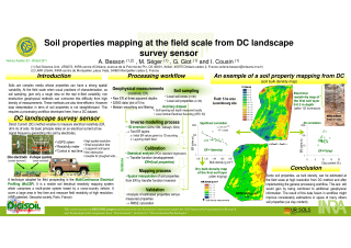
Electrical resistivity (or electrical conductivity) can be measured by non-destructive methods as Direct Current (DC) method. The basic principle of DC method consists 1) in generating an electrical current at low signal frequency into soil by the use of a pair of electrodes and then 2) in measuring the consequent electrical potential by the use of two other electrodes. Electrical potential is then converted into resistivity (ohm m). Resistivity corresponds then to the difficulty of the electrical current to cross the soil. Several DC techniques can be implemented to measure in space and in time the soil resistivity. The most general technique is the Electrical Resistivity Tomography (ERT). It enables to measure locally resistivity at high resolution in depth. Another technique more adapted for field prospecting is the MultiContinuous Electrical Profiling (MuCEP). It is a mobile soil electrical resistivity mapping system, i.e. a DC landscape survey sensor, which comprises a multi-probe system towed by a cross-country vehicle. It results from a considerable technological progress (ARP patented, Geocarta society, Paris, France) and can, therefore, cover a large area in few time and measure field resistivity at high resolution. Nevertheless when the MuCEP technique is relatively operational in field, the electrical resistivity, i.e. the product of MuCEP device, remains hard to interpret in term of a single soil property. Indeed resistivity depends on several soil variables which interact with each other. This large multi-dependency to soil properties is a consequence of the interaction between the electrical current flow and the media. For instance, resistivity decreases when the electrical flow is facilitated in soils, i.e. when these last ones are wet, clayey, or/and compacted. This study was part of the DIGISOIL project and hence financed by the European Commission under the 7th Framework Programme for Research and Technological Development, Area “Environment”, Activity 6.3 “Environmental Technologies”. It aimed at mapping several soil properties from MuCEP measurements obtained at the field scale and at high resolution. Processing steps gathered resistivity filtering and smoothing, transfer function development and geostatistical mapping. Calibration and validation steps were realized from in-field soil coring. Several soil properties, as water content, bulk density, clay content, were estimated in space and thus mapped at the field scale and at high resolution. We discussed then on the efficiency of DC landscape survey for soil properties mapping, on estimates of uncertainties and main drawbacks and benefits of the in-field DC method.
Fichier principal
 2011_Besson_EGU_poster_1.pdf (2.77 Mo)
Télécharger le fichier
2011_Besson_EGU_2.pdf (39.89 Ko)
Télécharger le fichier
2011_Besson_EGU_poster_1.pdf (2.77 Mo)
Télécharger le fichier
2011_Besson_EGU_2.pdf (39.89 Ko)
Télécharger le fichier
| Origine | Fichiers éditeurs autorisés sur une archive ouverte |
|---|
| Origine | Fichiers produits par l'(les) auteur(s) |
|---|